



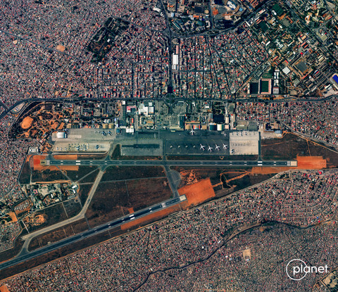
LUANDA, Angola, Nov. 4, 2026 (XOL Africa) — US satellite imaging company Planet Labs has released its first images of Angola’s capital, Luanda, captured by its latest high-resolution Earth observation satellite, demonstrating technology designed to improve the monitoring of urban development, infrastructure and environmental changes.
In a statement issued from San Francisco, Planet Labs said its Pelican-12 satellite captured images of Luanda and Quatro de Fevereiro International Airport on October 30 from an altitude of approximately 589 kilometres, following its launch aboard SpaceX’s Bandwagon-5 mission from Cape Canaveral Space Force Station in Florida.
The images mark the first publicly released observations from the spacecraft, which forms part of Planet’s second-generation Pelican constellation and is designed to provide increasingly detailed views of the Earth’s surface.
The selection of Luanda for the satellite’s first released imagery places Angola’s largest city among the early locations used to demonstrate the company’s latest Earth observation capabilities.
Luanda, a major economic and commercial centre in southern Africa, has experienced decades of urban expansion, creating growing demand for infrastructure investment, transport planning and environmental management.
High-resolution satellite imagery could provide additional tools for monitoring construction activity, changes in land use, coastal development and transport networks across the Angolan capital.
Such applications could be particularly relevant for Angola as the country seeks to diversify its oil-dependent economy and expand investment in logistics, infrastructure and other sectors.
However, Planet did not announce any commercial agreement with the Angolan government or indicate that the images were captured under a specific project in the country.
The company said Pelican-12 was its first satellite capable of producing imagery in the 30-centimetre resolution class, a significant improvement in the level of detail available from its latest spacecraft.

The satellite will initially deliver imagery at approximately 50-centimetre resolution, with the company targeting 30-centimetre imagery once it reaches its lower operational orbit.
At that resolution, satellite images can reveal finer details of buildings, roads, industrial installations and other physical infrastructure, potentially improving the quality of geospatial analysis.
Pelican-12 also carries NVIDIA’s Jetson computing platform, enabling artificial intelligence processing aboard the spacecraft rather than relying entirely on ground-based systems.
The onboard technology could help accelerate the processing of imagery and support more efficient delivery of information to customers.
Planet said the spacecraft was also testing a new communications package intended to reduce the time between capturing satellite imagery and delivering the data.
For African governments and businesses, faster access to detailed Earth observation data could support applications ranging from agricultural monitoring and disaster response to infrastructure management and maritime surveillance.
The company has not disclosed specific plans to deploy Pelican-12 services in Angola.
James Mason, chief space officer at Planet, said the first images demonstrated that the satellite was operating as expected following launch.
“This crisp first image tells us that Pelican-12 is healthy and performing well after launch,” Mason said.
“Each new Pelican we launch gives us lessons for the next build. For example, the updated payload and communication systems on Pelican-12 are informed by Pelican-11, our engineering pathfinder launched in July.”
He said additional Pelican launches planned for 2027 would help expand the company’s artificial intelligence-enabled satellite constellation in response to rising demand for high-resolution geospatial information.
Pelican-12 is Planet’s 25th satellite placed into orbit this year across four launches, reflecting the company’s efforts to expand its imaging capacity and shorten the time required to deploy new spacecraft.
The expansion has been supported by the opening of a manufacturing facility in Berlin in September, which Planet said would strengthen production capabilities for its satellite services business.
The company has also secured agreements with the governments of Japan, Sweden and Germany to develop dedicated satellite capabilities, reflecting growing demand for sovereign access to Earth observation technology.
Planet, which is listed on the New York Stock Exchange under the ticker PL, operates a commercial Earth observation fleet supplying imagery and geospatial data to customers in agriculture, forestry, finance, intelligence and government.
For Angola, the release illustrates the increasing availability of detailed satellite observations of African cities, even as access to advanced imaging technology remains largely dependent on international commercial operators.
The development also highlights the potential for satellite data to support urban planning and infrastructure investment across Africa, where rapid population growth and expanding metropolitan areas are increasing the need for reliable geographic information.
Planet said Pelican-12 was continuing its calibration process and approaching its final operational orbit, with further improvements in image quality expected as the spacecraft becomes fully operational.
The company plans additional launches in 2027 as it expands its high-resolution imaging constellation and satellite services business.
SUPPORT AFRICAN BUSINESS JOURNALISM
Help XOL Africa expand independent business reporting across Africa.
SUPPORT XOL AFRICA →